|
|
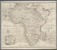
An Accurate Map of Africa Dr…
Africa
Bowen, Emanuel, d. 1767
No date
| Title |
An Accurate Map of Africa Drawn from the best Authorities. |
| Publisher |
Bowen, Emanuel, d. 1767 |
| Publication Date |
No date |
|
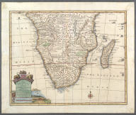
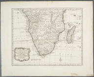
A new and accurate map of th…
Southern Africa
Bowen, Emanuel, d. 1767
1747
| Title |
A new and accurate map of the southern parts of Africa Containing Lower Guinea, Monoemugi, Zanguebar, the Empire of Monomotapa, Country of the Cafres &c. and the Island of Madagascar. Drawn from the best Authorities, assisted by the most approved Charts and Maps and adjusted by Astron. Observations. |
| Publisher |
Bowen, Emanuel, d. 1767 |
| Publication Date |
1747 |
|
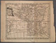
A new and accurate map of Ne…
Western Africa
Bowen, Emanuel, d. 1767
1747
| Title |
A new and accurate map of Negroland and the Adjacent Countries; also Upper Guinea showing the principal European Settlements, and distinguishing those belonging to England, Denmark and Holland. The Sea Coast and some of the Rivers being drawn from Surveys and the best modern Maps and Charts ... |
| Publisher |
Bowen, Emanuel, d. 1767 |
| Publication Date |
1747 |
|
A new and correct map of Afr…
Africa
Bowen, Emanuel, d. 1767
1748
| Title |
A new and correct map of Africa. Drawn from the most approved modern maps and charts, and adjusted by astronomical observations representing also the course of the Trade Winds, Monsoons &c. |
| Publisher |
Bowen, Emanuel, d. 1767 |
| Publication Date |
1748 |
|
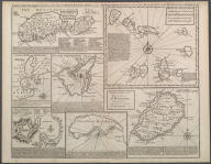
Particular draughts of some …
African islands
Bowen, Emanuel, d. 1767
1752
| Title |
Particular draughts of some of the chief African Islands in the Mediterranean, as also in the Atlantic and Ethiopic Oceans. |
| Publisher |
Bowen, Emanuel, d. 1767 |
| Publication Date |
1752 |
|
Nieuwe en Naauwkerige Kaart …
Southern Africa
Bowen, Emanuel, d. 1767
1782
| Title |
Nieuwe en Naauwkerige Kaart van het Zuidlyk Gedeelte van Africa ... verbeeterd door W.A. Bachiene. |
| Publisher |
Bowen, Emanuel, d. 1767 |
| Publication Date |
1782 |
|
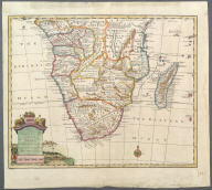
A new and accurate map of th…
Southern Africa
Bowen, Emanuel, d. 1767
1747
| Title |
A new and accurate map of the southern parts of Africa Containing Lower Guinea, Monoemugi, Zanguebar, the Empire of Monomotapa, Country of the Cafres &c. and the Island of Madagascar. Drawn from the best Authorities, assisted by the most approved Charts and Maps and adjusted by Astron. Observations. |
| Publisher |
Bowen, Emanuel, d. 1767 |
| Publication Date |
1747 |
|
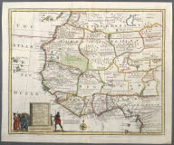
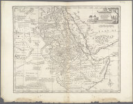
A New and Accurate Map of Nu…
Eastern Africa
Bowen, Emanuel, d. 1767
1750 - 60?
| Title |
A New and Accurate Map of Nubia & Abissinia, Together with all the Kingdoms Tributary Thereto and bordering upon them ... |
| Publisher |
Bowen, Emanuel, d. 1767 |
| Publication Date |
1750 - 60? |
|
|