|
|
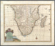
A new and accurate map of th…
Southern Africa
Bowen, Emanuel, d. 1767
1747
| Title |
A new and accurate map of the southern parts of Africa Containing Lower Guinea, Monoemugi, Zanguebar, the Empire of Monomotapa, Country of the Cafres &c. and the Island of Madagascar. Drawn from the best Authorities, assisted by the most approved Charts and Maps and adjusted by Astron. Observations. |
| Publisher |
Bowen, Emanuel, d. 1767 |
| Publication Date |
1747 |
|
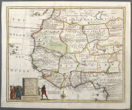
A new and accurate map of Ne…
Western Africa
Bowen, Emanuel, d. 1767
1747
| Title |
A new and accurate map of Negroland and the Adjacent Countries; also Upper Guinea showing the principal European Settlements, and distinguishing those belonging to England, Denmark and Holland. The Sea Coast and some of the Rivers being drawn from Surveys and the best modern Maps and Charts ... |
| Publisher |
Bowen, Emanuel, d. 1767 |
| Publication Date |
1747 |
|
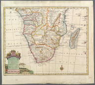
A new and accurate map of th…
Southern Africa
Bowen, Emanuel, d. 1767
1747
| Title |
A new and accurate map of the southern parts of Africa Containing Lower Guinea, Monoemugi, Zanguebar, the Empire of Monomotapa, Country of the Cafres &c. and the Island of Madagascar. Drawn from the best Authorities, assisted by the most approved Charts and Maps and adjusted by Astron. Observations. |
| Publisher |
Bowen, Emanuel, d. 1767 |
| Publication Date |
1747 |
|
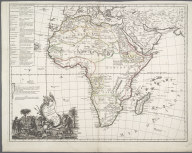
L'Afrique Suivant les Dernie…
Africa
Le Rouge, Georges-Louis
1747
| Title |
L'Afrique Suivant les Derniers Observations de Mr. Hass et des RRPP Jesuites. |
| Publisher |
Le Rouge, Georges-Louis |
| Publication Date |
1747 |
|
|