Detail View: Maps of Africa: Carte Particuliere des Costes de L'Afrique qui Comprend le Pays de Cafres &c. Levee par Ordre Expres des Roys de Portugal sous qui on en a Fait la Decouverte.
|
Title:
|
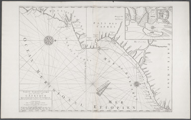
Carte Particuliere des Costes de L'Afrique qui Comprend le Pays de Cafres &c. Levee par Ordre Expres des Roys de Portugal sous qui on en a Fait la Decouverte.
|
|
Title in Translation:
|
Specific map of the African coast including Caffraria.
|
|
Publication Place:
|
Amsterdam
|
|
Publisher:
|
Mortier, Pierre
|
|
Publication Date:
|
1700
|
|
Cartographer:
|
Mortier, Pierre
|
|
Height:
|
57 cm.
|
|
Width:
|
82 cm.
|
|
Scale:
|
Scale in French, English, German, Spanish and Portuguese leagues
|
|
Color:
|
Uncolored
|
|
Descriptive Notes:
|
Indicates many rivers and settlements discovered by the Portuguese. The sea contains a sixteen-point compass rose with rhumb lines. Inset: Island of Inhancato and the fortress of Sofala.
|
|
Provenance:
|
Dr. Oscar I. Norwich
|
|
General Area:
|
Oceans
|
|
Geographic Focus:
|
Oceans
|
|
Map Use:
|
Sea chart
|
|
Period:
|
17th c.
|
|
Norwich Number:
|
263
|
|
Call Number:
|
NOR 0263
|
|
References:
|
Norwich (2nd ed.), ckey = 3871463
|
|
Page:
|
map 0263, p. 300
|
|
Program:
|
Jacobson Africana Program
|