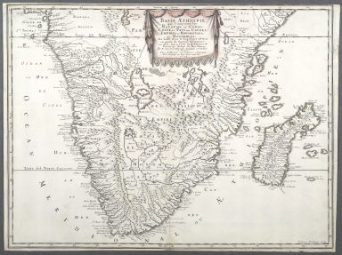
Detail View: Maps of Africa: Basse Aethiopie qui Comprend les Royaume de Congo, Coste, et Pays des Cafres, Empires du Monomotapa, et Monoemugi.
|
Title:
|
Basse Aethiopie qui Comprend les Royaume de Congo, Coste, et Pays des Cafres, Empires du Monomotapa, et Monoemugi.
|
|
Title in Translation:
|
Southern Africa comprising the kingdom of Congo, coast of Kaffraria, empires of Monomotapa and Monoemugi.
|
|
Publication Place:
|
Paris
|
|
Publisher:
|
Mariette, Pierre, 1603-1657
|
|
Publication Date:
|
1655
|
|
Cartographer:
|
Sanson, Nicolas, 1600-1667
|
|
Engraver:
|
Pruthenus, Jean Somers
|
|
Height:
|
42 cm.
|
|
Width:
|
56 cm.
|
|
Scale:
|
No scale given
|
|
Color:
|
Colored
|
|
Descriptive Notes:
|
"The fictitious states are given fictious boundaries and the interior is marked with large cities such as Vigiti Magna and Monomotapa."
|
|
Provenance:
|
Dr. Oscar I. Norwich
|
|
General Area:
|
Africa
|
|
Geographic Focus:
|
Southern Africa
|
|
Period:
|
17th c.
|
|
Norwich Number:
|
158
|
|
Call Number:
|
NOR 0158
|
|
References:
|
Norwich (2nd ed.), ckey = 3871463
|
|
Page:
|
map 0158, p. 180
|
|
Program:
|
Jacobson Africana Program
|