Detail View: Maps of Africa: Charte von Africa nach astronomischen Beobachtungen, auch alten und neuen Nachrichten, ingleichen den Charten von Sayer, Rennel, Arrowsmit ...
|
Title:
|
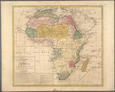
Charte von Africa nach astronomischen Beobachtungen, auch alten und neuen Nachrichten, ingleichen den Charten von Sayer, Rennel, Arrowsmit ...
|
|
Title in Translation:
|
Map of Africa according to astronomical observations and information found on the maps of Sayer, Rennel and Arrowsmith.
|
|
Publication Place:
|
Nuremberg
|
|
Publisher:
|
Homann Erben (Firm)
|
|
Publication Date:
|
1797
|
|
Cartographer:
|
Gussefeld, F. L. (Franz Ludwig), 1744-1807
|
|
Height:
|
46 cm.
|
|
Width:
|
15.5 cm.
|
|
Scale:
|
Scale in German, French, English and Portuguese miles, nautical miles
|
|
Color:
|
Colored
|
|
Descriptive Notes:
|
Note states "accurate geographical knowledge of the interior will only be available after further exploration"; Prime meridian through Ferro Island.
|
|
Provenance:
|
Dr. Oscar I. Norwich
|
|
General Area:
|
Africa
|
|
Geographic Focus:
|
Africa
|
|
Period:
|
18th c.
|
|
Norwich Number:
|
112
|
|
Call Number:
|
NOR 0112
|
|
References:
|
Norwich (2nd ed.), ckey = 3871463
|
|
Page:
|
map 0112, p. 130
|
|
Program:
|
Jacobson Africana Program
|