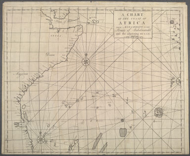
Detail View: Maps of Africa: A chart of the coast of Africa from Mozambique to the Straits of Babelmandel and the adjoyning Ocean.
|
Title:
|
A chart of the coast of Africa from Mozambique to the Straits of Babelmandel and the adjoyning Ocean.
|
|
Publication Place:
|
London
|
|
Publisher:
|
Knapton, James, d. 1738; Knapton, John, 1696-1770
|
|
Publication Date:
|
1728
|
|
Cartographer:
|
Knapton, James, d. 1738; Knapton, John, 1696-1770
|
|
Height:
|
48 cm.
|
|
Width:
|
58 cm.
|
|
Scale:
|
Scale in English leagues
|
|
Color:
|
Uncolored
|
|
Descriptive Notes:
|
Chart includes the Horn of Africa and numerous islands in the Indian Ocean. The compass roses radiate numerous rhumb lines.
|
|
Provenance:
|
Dr. Oscar I. Norwich
|
|
General Area:
|
Oceans
|
|
Geographic Focus:
|
Eastern Africa
|
|
Map Use:
|
Sea chart
|
|
Period:
|
18th c.
|
|
Norwich Number:
|
271
|
|
Call Number:
|
NOR 0271
|
|
Source:
|
Atlas Maritimus et Commercialis (1728)
|
|
References:
|
Norwich (2nd ed.), ckey = 3871463
|
|
Page:
|
map 0271, p. 309
|
|
Program:
|
Jacobson Africana Program
|