Detail View: Maps of Africa: Vue et Description du Cap de Bonne Esperance.
|
Title:
|
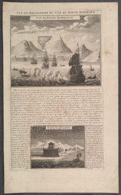
Vue et Description du Cap de Bonne Esperance.
|
|
Title in Translation:
|
View and description of the Cape of Good Hope.
|
|
Publication Place:
|
Paris
|
|
Publisher:
|
Chatelain, Henri Abraham; Gueudeville, Nicolas, ca. 1654-ca. 1721.
|
|
Publication Date:
|
1705-1720
|
|
Cartographer:
|
Chatelain, Henri Abraham
|
|
Physical Description:
|
Copperplate
|
|
Height:
|
35.5 cm.
|
|
Width:
|
21 cm.
|
|
Scale:
|
No scale given
|
|
Color:
|
Uncolored
|
|
Descriptive Notes:
|
Two views of the Cape. Inset: Le fort des Hollandois au Cap du Bonne Esperance. Top right: Tom. VI, No. 17, Pag. 74.
|
|
Provenance:
|
Dr. Oscar I. Norwich
|
|
General Area:
|
Africa
|
|
Geographic Focus:
|
Cape of Good Hope
|
|
Period:
|
18th c.
|
|
Norwich Number:
|
210
|
|
Call Number:
|
NOR 0210
|
|
Source:
|
Atlas Historique et Methodique (1705-20)
|
|
References:
|
Norwich (2nd ed.), ckey = 3871463
|
|
Page:
|
map 0210, p. 237
|
|
Program:
|
Jacobson Africana Program
|