Detail View: Maps of Africa: Totius Africae tabula et descriptio universalis etiam ultra Ptolemaei limites extensa.
|
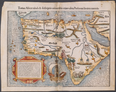
Title:
|
Totius Africae tabula et descriptio universalis etiam ultra Ptolemaei limites extensa.
|
|
Title in Translation:
|
Map of the whole of Africa based on Ptolemaic sources.
|
|
Publication Place:
|
Basel
|
|
Publisher:
|
Munster, Sebastian, 1489-1552
|
|
Publication Date:
|
1542
|
|
Cartographer:
|
Munster, Sebastian, 1489-1552
|
|
Physical Description:
|
Woodcut
|
|
Height:
|
26 cm.
|
|
Width:
|
34 cm.
|
|
Scale:
|
No scale given
|
|
Color:
|
Colored
|
|
Descriptive Notes:
|
Latin edition of Munster's map (see NOR 0002). Includes three places printed upside down: Quiloa, Mantes and Regnu[m].
|
|
Provenance:
|
Dr. Oscar I. Norwich
|
|
General Area:
|
Africa
|
|
Geographic Focus:
|
Africa
|
|
Period:
|
16th c.
|
|
Norwich Number:
|
3
|
|
Call Number:
|
NOR 0003
|
|
Source:
|
Geographia Universalis (1540-1542) (Latin edition)
|
|
References:
|
Norwich (2nd ed.), ckey = 3871463
|
|
Page:
|
map 0003, p. 6
|
|
Program:
|
Jacobson Africana Program
|