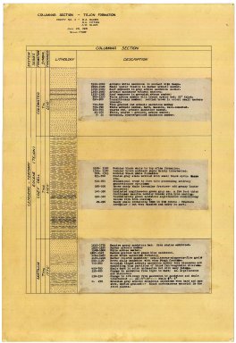
Detail View: Stanford Geological Survey: Columnar section
|
Title:
|
Columnar section
|
|
Primary Creator:
|
Durbin, R. A.
|
|
2nd Creator:
|
Fitting, R. U.
|
|
3rd Creator:
|
Black, A. W.
|
|
Date:
|
1931
|
|
Coordinates:
|
(W 119°07'30"--W 119°00'00"/N 34°22'30"--N 34°15'00").
|
|
Scale:
|
Scale varies.
|
|
Dimensions:
|
56 cm. or smaller.
|
|
Notes:
|
Accompanied by 8 field notebooks.; No. 2 is a sketch map.; No. 9, 14 and 18 include fold-out topographical map in back pocket.; Pen-and-ink and colored pencil.
|
|
Related Items:
|
[No. 1] -- Columnar section : Sespe Formation, Upper Ojai Valley / by Ambrose, Birch and Clark -- [no. 2] -- Sketch map of drainage & geology, East sec't., South Mt. / [by] Gabbert, Isaacs, Kirwan and Kuhlen -- [no. 3] -- Columnar section / [by] Kirwan -- [no. 4] -- Sisar Creek area / by E.H. Blade -- [no. 5] -- Columnar section of Modelo, as found in Fresno Canyon / [by] Capito [and] Storey -- [no. 6] -- Santa Margarita columnar section / [by] Spencer [and] Dorn -- [no. 7] -- Columnar section, Rincon and Vaqueros / by Kuhlen -- [no. 8] -- Columnar section -- Tejon Formation / [by] Durbin, Fitting [and] Black -- [no. 9] -- Columnar section / [by] Gabbert & Isaacs -- [no. 10] -- The undifferentiated Eocene of the North Fork of Matilija Creek / [by] Lund [and] Avery -- [no. 11] -- Saugus Formation in Hall Canyon, Ventura quadrangle / [by] F.A. Johnson.
|
|
Subjects:
|
Geology -- California -- Ventura -- Maps; Ventura County (Calif.) -- Maps
|
|
Catalog Key:
|
5405114
|