Detail View: Stanford Geological Survey: Areal geology and Brunton surveying measurements west and south of the city of San Juan Bautista, California
|
Title:
|
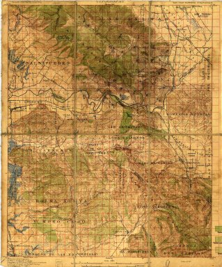
Areal geology and Brunton surveying measurements west and south of the city of San Juan Bautista, California
|
|
Primary Creator:
|
Stanford Geological Survey.
|
|
Date:
|
1924
|
|
Coordinates:
|
(W 121°15'00"--W 121°00'00"/N 36°45'00"--N 36°30'00").
|
|
Scale:
|
Scale 1:62,500
|
|
Dimensions:
|
on sheet 49 x 40 cm.
|
|
Notes:
|
No. 1-8 are topographical maps.
|
|
Related Items:
|
[No. 1] -- Areal geology and Brunton surveying measurements west and south of the city of San Juan Bautista -- [no. 2] -- Cross sections from 1-13 N.W. of the city of San Juan Bautista -- [no. 3] -- Primary triangulation [San Juan Bautista quadrangle] -- [no. 4] -- Areal geology and Brunton surveying measurements throughout the [San Juan Bautista] Quad -- [no. 5] -- Brea deposits [San Juan Bautista quadrangle] -- [no. 6] -- Contouring on the Santa Cruz Mountains [San Juan Bautista quadrangle] -- [no. 7] -- Santa Cruz Mountains strike & dip measurements [San Juan Bautista quadrangle] -- [no. 8] -- Topo areas on the Santa Cruz Mountains from 1 to 20 for 1923 [San Juan Bautista quadrangle]
|
|
Subjects:
|
Geology -- California -- Monterey County -- Maps; Geology -- California -- San Benito County -- Maps; Monterey County (Calif.) -- Maps; San Benito County (Calif.) -- Maps
|
|
Catalog Key:
|
5332767
|