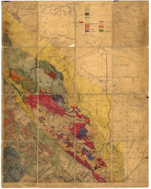
Detail View: Stanford Geological Survey: California
|
Title:
|
California
|
|
Primary Creator:
|
Marshall, R. B.
|
|
Date:
|
1895
|
|
Coordinates:
|
(W 122°13'--W 122°10'/N 37°26'--N 37°24').
|
|
Scale:
|
Scale [1:540,000]. 1" = 45000'.
|
|
Dimensions:
|
65 x 51 cm.
|
|
Notes:
|
At bottom left : "Henry Gannett, Chief Topographer. R.U. Goode, Geographer in charge. Triangulation by U.S.C. & G. Survey."; Includes areal geology.; Pen-and-ink and watercolor on cloth.
|
|
Subjects:
|
Geology -- California -- Stanford -- Maps, Manuscript; Palo Alto Region (Calif.) -- Maps, Manuscript; Palo Alto Region (Calif.) -- Maps, Topographic
|
|
Catalog Key:
|
4793992
|