Detail View: Stanford Geological Survey: Smale's ranch area
|
Title:
|
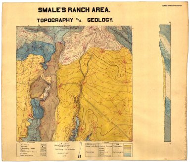
Smale's ranch area
|
|
Primary Creator:
|
Wilde, F. L.
|
|
2nd Creator:
|
Halliday, T. W.
|
|
3rd Creator:
|
Young, H. W.
|
|
Date:
|
1910
|
|
Coordinates:
|
(W 118°45'00"--W 118°30'00"/N 34°15'00"--N 34°00'00").
|
|
Scale:
|
Scale [1:4,800]. 1" = 400'.
|
|
Dimensions:
|
on sheet 46 x 53 cm.
|
|
Notes:
|
Accompanied by 3 field notebooks.; Includes cross section.; Includes geological legend and culture.; No. 1, copies 2-4 are partially colored maps on traceable paper.; No. 1, copies 5-7 are blue prints, and missing.; No. 4 is a field map that is pen-and-ink on cloth.; No. 56 triangulation notebook on "Los Dedos area : geology and topography" record.; Nos. 2-3 are pen-and-ink and watercolor on cloth.; Pen-and-ink and watercolor on cloth.; Relief shown by contours and spot heights.
|
|
Related Items:
|
[No. 1.1] Smale's ranch area: topography and geoogy / by Wilde, Halliday, and Young; Young draftsman -- [no. 2] Smale's ranch area: topography and geology / by Wilde, Young, and Halliday; Halliday draughtsman -- [no. 3] Smale's ranch area: topographic-geological map / by halliday, Young, and Whilde; draftsman Wilde -- [no. 4] Smale's ranch area: topography / by Halliday, Young, and Wilde.
|
|
Subjects:
|
Calabasas (Calif.) -- Maps, Manuscript; Calabasas (Calif.) -- Maps, Topographic
|
|
Catalog Key:
|
4790609
|