Detail View: Stanford Geological Survey: Cooksey sheet
|
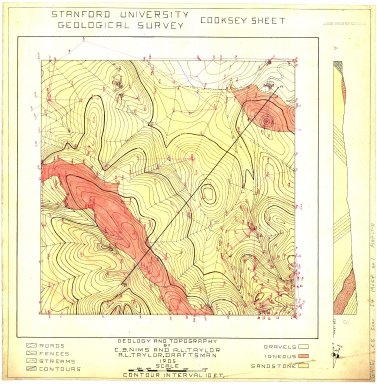
Title:
|
Cooksey sheet
|
|
Primary Creator:
|
Taylor, A. L.
|
|
2nd Creator:
|
Nims, C. B.
|
|
Date:
|
1905
|
|
Coordinates:
|
(W 122°15'00"--W 122°00'00"/N 37°30'00"--N 37°15'00").
|
|
Scale:
|
Scale [1:4,800]. 1" = 400'.
|
|
Dimensions:
|
50 x 49 cm.
|
|
Notes:
|
Accompanied by triangulation notebook.; Contour interval 10 ft.; Includes cross section.; Includes geological legend.; No. 1, copies 3-4 are blue line prints.; No. 1, copy 2 and no. 2, copy 2 are uncolored maps on traceable paper.; No. 2 is pen-and-ink on paper.; Pen-and-ink on paper.; Relief shown by contours and spot heights.
|
|
Related Items:
|
Maps: [No. 1] -- Cooksey sheet : geology and topography
|
|
Subjects:
|
Palo Alto Region (Calif.) -- Maps, Manuscript; Palo Alto Region (Calif.) -- Maps, Topographic
|
|
Catalog Key:
|
4776601
|