Detail View: Stanford Geological Survey: Geologic map of part of the Santa Ynez River Region
|
Title:
|
Geologic map of part of the Santa Ynez River Region
|
|
Primary Creator:
|
Stanford Geological Survey.
|
|
Date:
|
1947]
|
|
Scale:
|
Scale 1:31,680.
|
|
Dimensions:
|
55 x 55 cm.
|
|
Notes:
|
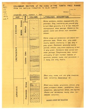
Accompanied by Wasson and Webster field reports.; Accompanied by: Santa Ynez Region cross sections / E. Wasson [and] C. Webster -- Columnar section A ... rocks of anticline north of Santa Ynez River between Mono Creek and north folk of Juncal Creek -- Columnar section B, rocks along the Santa Ynez River -- Columnar section of the rocks of the Santa Ynez range from the Matilija Formation to Blue Canyon.; Cross section and columnar sections folded in back pocket of Wasson field report.; Pen-and-ink and typescript title and explanation affixed to U.S. Geological Survey topographic map.; Relief shown by contours and spot heights.
|
|
Alternate Title:
|
Santa Ynez Region columnar sections.; Santa Ynez Region cross sections.
|
|
Subjects:
|
Geology -- California -- Santa Ynez River Area -- Maps; Santa Ynez River Area -- Maps
|
|
Catalog Key:
|
3926415
|